
Finding one’s way in the environment needs knowledge of the cardinal point as well as the landmarks in the environment and knowledge of the meaning of the symbols for representing important landmarks. Without the knowledge of how the environment physically and on paper ,one necessarily wastes a whole lot of time in dealing effectively with one’s environment. Many people, therefore ,find it difficult finding their way around because of inadequate knowledge of cardinal points, landmarks and symbols .Knowledge of the cardinal point is therefore , necessary for all of us.
SHOWING DIRECTION USING THE CARDINAL POINTS AND THE OUTSTANDING LANDMARKS.
There are two main ways of showing direction of places or objects on maps. These are CARDINAL POINTS And ANGULAR BEARINGS.
THE FOUR CARDINAL POINTS
The cardinal points are the principal of the compass. That is we ,we have four names to describe directions -East, West, North and South. These four main directions are known as the Cardinal points of the compass. So the four main points of the compass are : NORTH ,SOUTH ,EAST AND WEST.
COMPASSS
A Compass is an instrument which shows directions. It has needle which turns round.
The compass is made in such a way that when the needle is at rest, it always points to the NORTH. The face of the compass looks like a wall clock. The compass has four cardinal points :North ,South, East and West.


The eight cardinal points of a compass.
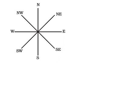
South -West is the opposite of North – East. In the same to way ,the direction in the middle of NORTH AND WEST Must also be called OPPOSITE TO SOUTH -WEST. We must always remember that North and south points are always mentioned first before EAST AND WEST.
HOW DO WE DETERMINE THE CARDINAL POINTS WITH THE POSITION OF THE SUN
To determine the cardinal points, we first look for the position of the Sun. The East is
the direction from where the sun rises. The West is the opposite of East. This means the West is the direction where the sun sets.
FACTORS TO BE CONSIDERED WHEN FINDING ONES WAY HOME WHEN LOST.
- THE DIRECTION OF THE SUN : Remember the sun rises from the East and sets in the West. If you stand straight and stretch your right arm to the East and left arm to the West then you will be facing South .You can now know whether to go Northward ,Southward ,Eastward or Westward.
2 . THE USE OF THE COMPASS: The compass can show us the cardinal points and where to go. To use the compass we turn it until the compass needle and the line North are together and the needle is pointing to the North (0degrees ). This will let you know the North direction then you find the rest and your way home.
3. LANDMARK OR THE CHARACTERISTICS OF THE ENVIRONMENT FROM WHERE YOU CAME TO THE NEXT: Landmarks are important features which are easily identifiable. They can be seen from a distance so we can use them to give direction eg. One can use a mountain from a far distance to locate a town which is nearer to that mountain.
4 . WE CAN USE BEARINGS TO FIND OUR WAY HOME : Bearing is the direction or position of a place in relation to a fixed point measured in degrees eg. if your town is in North-East of another town then its bearing is 45degrees from that town.

5 . SHOUTING FOR HELP: We can shout for help from People nearby.
BEARING
bearing is the direction or position in relation to a fixed point measured in degrees. Bearings are taken from North in a clockwise direction. By clockwise direction we mean moving from North O degrees to East 90 degrees to South 180 degrees to West 270 degrees. Then back to North again 360 degrees. So you move as the clock moves.
Bearing is a more accurate way of locating places because it can be measured by means of a protractor on paper and the Prismatic Compass on the ground. Eg. If you standing at Kumasi (fixed point), the bearing of Accra from Kumasi is 128 degrees. The bearing of Bolgatanga from Kumasi is 150, the bearing of Wa from Kumasi is 3500.
is a symbol usually placed at one corner of a map. It shows the ardinal points,’ Mostly the North is shown. With this; you can find the rest,
Iber the direction is always given from one point to another point. It is always